This Blog is part of the assessment for the NOR-R-AM/GEO-DEEP9500 course “Arctic tectonics, volcanism and climate.”
By Thomas Birchall (UNIS), Paul Heckmann (UiT), Cheng-Cheng Wang (UiB)
Three major magmatic events: the Sibirian Traps, the High Arctic Large Igneous Province (HALIP) and the North Atlantic Igneous Province (NAIP) in the Arctic region are introduced in the following. These events are classified as large igneous provinces (LIBs), periods during Earth’s history when large volumes of magma (> 0.1 million km3) have been produced and erupted over a wide area in a relative short period of time (c. 1-5 Myr), driving by large mantle-derived thermal and material fluxes into the shallow crust, independent of regional plate tectonics prior to emplacement (Coffin & Eldholm, 1994; Svensen, et al., 2009). The LIBs presented here are mainly discussed in terms of their timing, composition, geochemistry, origin and formation as well as climatic related impacts. This essay also includes studies based on outcrops in Svalbard, where evidences of numerous Arctic volcanic events and their effects can be traced and correlated (Fig. 1).

Siberian Traps
Overview
The Siberian Traps are a large igneous province (LIP) covering an area of approximately 7 million sq. km. in Siberia, Russia (Ivanov et al, 2013). The Siberian Traps were formed during a major volcanic event and is widely attributed to the “Great Dying” extinction event at the Permo-Triassic boundary (Wignall et al, 1992). Svalbard is one of the few locations where an extensive stratigraphy of the Permian-Triassic boundary is preserved and exposed.
Because the thickness of the LIP is unknown in many parts of the province, calculations of present-day volumes are very challenging to carry out (Reichow et al, 2009). Estimating original volcanic volumes is even more challenging with numerous published calculations. However, even a minimum possible original volume of approximately 3 million km3 (Reichow et al, 2002) highlights the magnitude of the event.
Geochronology
Argon isotope (Ar40/Ar39) dating indicates the majority of volcanism occurred at 250 Ma at the Permian-Triassic boundary over a relatively short period (Reichow et al, 2009).
Formation
There is some uncertainty as to the causal mechanism behind the formation of the Siberian traps, although the more widely favoured hypothesis is through mantle plume activity (Saunders et al, 2005). However, the lack of any associated uplift, as would be expected with a buoyant mantle plume, and any preceding or succeeding plume trail (e.g. Decan traps and the Chagos-Laccadive Islands or Yellowstone and the Snake River Plain) have led to the proposal of several other mechanism (e.g. Jones et al, 2002). Regardless of the causal mechanism, the volcanism has been well dated to coincide with the Permo-Triassic extinction event at numerous sites around the world (Reichow et al, 2009).
The province is comprised predominantly of flood basalts and is exposed on the Siberian Craton. To the west of the craton are major rift systems of the West Siberian Basin. Saunders et al (2005) argue that magma likely originated beneath the rift systems and not the craton, based on industry seismic data and stratigraphy. They also indicate rifting, with a beta factor (stretching of the lithosphere) of 1.6, initiated due a mantle plume.
Correlation with the Permian-Triassic extinction event
The Permian-Triassic extinction event is the most severe known extinction event in Earth’s history with over 90% of marine species and 70% of land vertibrates estimated going extinct due to major climate change and oceanic anoxia from the release of carbon dioxide and other associated greenhouse gasses (Sahney & Benton, 2008). The event also caused a gap in any record of coal development until the mid-Triassic due to the extinction and slow recovery of peat forming plants (Gregory et al, 1996). In addition to a clear change in biodiversity of the boundary, it is also marked by rapid changes in geochemistry and rock facies throughout the globe. Svalbard in the high Arctic is an example of where the Permian-Triassic boundary is well exposed having numerous geochemical, isotope and biostratigraphic studies carried out on the archipelago (e.g. Wignall et al, 2013; Algeo et al, 2012).

It has been hypothesised that the volcanism alone could not have produced the carbon dioxide required alone to trigger the mass extinction. Significant amounts of terrestrial char (coal soot) have been recorded in time equivalent rocks in the high arctic (Grasby et al, 2011). It is hypothesised that during emplacement of intrusive basalts caused large scale metamorphism of Siberian coal measures and organic rich shales (Fig. 2, upper right; Ogden et al, 2012), resulting in the release of large quantities of methane. Methane is a more potent greenhouse gas albeit short lived but breaks down, to essentially become carbon dioxide. Another hypothesis suggests volcanism may have aided the growth of methane producing microbes (Rothman et al, 2014).
Related studies in Svalbard
The Permian-Triassic transition is marked on Svalbard by the Kapp Starostin and Vikinghøgda Formations. The Permian Kapp Starostin formation is comprised of spiculitic cherts with interbedded shales whilst the Vikinghøgda is a marine shale. The Permian-Triassic boundary, more precisely, is located near the base of the Vikinghøgda shale and has been studied in numerous locations in Svalbard (Dustira et al, 2013; Bond & Wignall, 2010; Wignall et al, 1997).
Geochemically the boundary is marked by a negative carbon isotope excursion (Algeo et al, 2012) as shown in Fig. 2 left. Low diversity of palynomorphs and geochemical data from the Vikinghøgda formation indicate a highly stressed environment (Dustira et al, 2013). Studies of pyrite framboid diameters in the Vikinghøgda Formation, essentially an indirect indicator of paleo-bottom water conditions, also suggest the onset and prolonged period of anoxia at sea floor (Dustria et al, 2013), which was ultimately responsible for the extensive marine Permian-Triassic extinction. Similar evidence has been widely published from strata around the world, highlighting the global nature of the event and timing it occur at the time of the Siberian Trap flood basalts.
High Arctic Large Igneous Province
Overview
In the Late Mesozoic the arctic volcanism is linked to the opening of the Arctic oceans and the magmatic activity that has resulted in the High Arctic Large Igneous Province (HALIP, Fig. 1), a collective term defined by Tarduno et al. (1998). The linkage of the Mesozoic igneous rocks across the Arctic and their classification as a Large Igneous Province (LIP) can be traced back to Tarduno et al. 1996, who recognized the connection between igneous activity on the Alpha Ridge and Cretaceous magmatic provinces across the Arctic. Igneous rocks of the HALIP are exposed in Svalbard, Franz Josef Land, Offshore Barents Sea, the Canadian Arctic Islands (Queen Elizabeth Islands) and Peary Land in northern Greenland, areas that were peripheral during the development of the Amerasian Basin and the Alpha Ridge (Nejbert, et al., 2011).
Magmatic Volume
The continental crust influenced by HALIP magmatism is estimated to exceed 600,000 km2 and a conservative estimate indicates 150,000 km3 of magma is preserved in peripherical parts of the HALIP. However, the intrusive components in Franz Josef Land, North Greenland and Canadian Arctic are not accounted for the volume calculation and abundant volcanic detritus in Cretaceous strata of both Svalbard and Franz Josep Land indicate that a much larger volume was eroded (Maher, 2001).
Geochemistry
The dolerites of Svalbard are within-plate tholeiites and their trace-element geochemistry reflects their continental intra-plate setting (Nejbert, et al., 2011). The geochemical character of the dolerites from Svalbard is representative for rocks from other localities in the Arctic that are constitute part of the HALIP (Tarduno, et al., 1998; Maher, 2001). In this context similar geochemical affinities were described in rocks from Kong Karls Land, Franz Josef Land, from products of magmatism that were dredged from surrounding submarine rocks, the De Long Islands, the Canadian Arctic and Kap Washington in Greenland.
Geochronology
The age of the HALIP magmatism is still a subject of scientific debate, though at least 134 radiometric ages are reported in the literature (Senger, et al., 2014). Understanding the precise timing of the magmatism is crucial for correlating the variety of magmatic processes in the Arctic for possible detection of a hotspot trace, for models of plume development and global correlations (Corfu, et al., 2013; Maher, 2001). While the majority of the published ages based on the K-Ar and Ar-Ar systems the number of U-Pb ages on pegmatites is comparatively small, though the later can yield a more robust method to consolidate the chronological record (Corfu, et al., 2013). The Ar-Ar/K-Ar ages suggest a prolonged magmatism from c. 145 to 78 Ma with a peak at c. 120-110 Ma. In comparison, the U-Pb ages a indicate a much shorter magmatic event at ca. 124.5 Ma. The inconsistency of the K-Ar and Ar-Ar ages might lead back to an unstable Ar system, being affected by Ar overpressure, retrogression or recoil phenomena (Senger, et al., 2014).
Significance on global climate
The timing of the emplacement of LIPs, extinction events and rapid climate change strongly correlates during Earth’s history. Although the causes of mass extinctions are heatedly debated, LIPs are among the most cited explanations, however not all LIPs are accompanied by a mass extinction event and vice versa (Jones , et al., 2016). Large scale volcanism can have an impact on the conditions of ecosystems by causing alterations in the climate-sensitive carbon and sulphur cycle. Numerous and complex interactions and feedbacks between volcanism and these cycles make correlations of climate response to individual LIP emplacements challenging. Factors regulating the impact on the climate are among others: the mode of LIP emplacement, the host lithologies of intruded and extruded material, the eruption style and the timescale (Jones , et al., 2016). The following two examples clarify the effect of the host lithologies and eruption style. (1) The temporal correlation of the two largest mass extinction events, the end-Permian and Triassic-Jurassic with major intrusions of sills into evaporite-rich sedimentary basins led to the hypothesis that evaporite heating might be a significant factor for ecosystem crises (Svensen, et al., 2009). (2) The eruption style, respectively the intensity and height of the eruption column depends on the viscosity of the magma and therefore on the composition, especially the SiO2 and volatile content. The height of the eruption controls if volcanic particle are injected above the tropopause, where they have a considerably long life (Jones , et al., 2016) time as aerosol and therefore have an significant influence on the climate or if the volcanic particles are only transported into the atmosphere, where they precipitate in a relative short about of time, without affecting the climate in the same extent (Jones , et al., 2016). The emplacement of large volumes of magma from HALIP might be correlated to a global anoxic event (OAE1a), but this linkage needs further geochronological and stratigraphic studies across the Arctic to be validated (Senger, et al., 2014).
Comparison of HALIP Locations
The HALIP comprises volcanic domains (volcanoes, lava flows and ashes from eruptions) as well es sub-volcanic domains (plutons, sills and dikes emplaced in sedimentary basins or other shallow parts of the crust (Jerram & Bryan, 2015).
The mafic intrusions and extrusions of Svalbard show similarities with the Cretaceous magmatism that occurred in Franz Josef Land. In addition, stratigraphic correlations include a maximum Callovian transgression, a regression culminating in continental deposits in the Hauterivian and a Late Cretaceous gap and implied regression that was preceded by a transgression (Maher, 2001). Next to the same uplift/regression history in Cretaceous times, east Svalbard and Franz Josef Land share a similar contractional setting, followed by an extensional episode (Grogan, et al., 1998). Integrating these similarities indicate that the thermal effect of the HALIP extended more than 500 km into the continental margin of the Arctic Basin at Cretaceous times, including the intervening Lomonosov Ridge (Maher, 2001).
Mafic dike swarms in the North Greenland Area, locally reaching up to 50% of the rock volume are probably related to the HALIP. The dikes have high TiO2 levels and within plate mobile element characteristics. The age of the dikes is uncertain, however, the intrusions are on strike with volcanics of Ellesmere Island, whose ages are better constrained. In addition, besides similarities in REE patterns of two basalt flow samples with those of Svalbard a significant correlation to HALIP is given by the presence of lower Cretaceous terrestrial deposits, suggesting an uplift event (Maher, 2001).
The occurrence of flood basalts, dikes and sills of Cretaceous age in the Canadian Arctic Islands with a strong expression in Aptian-Albian correlates well with those of Svalbard and Franz Josef Land. In the Late Hauterivian fluvial plain deposits indicate a regression, contemporaneous with the regression in Franz Josef Land. After abundant extrusive rocks in the Aptian, a second regression and unconformity initiated in the Late Albian-Cenomanian, correlates with the timing of uplift, regression and erosion in Svalbard and Franz Josep Land, suggesting that the double pulse was a HALIP-wide feature (Maher, 2001).
Due to logistical challenges and an extensive sedimentary cover, knowledge about the Amerasian Basin is restricted. Constraining geophysical and geological evidence indicate an oceanic character of the Alpha Ridge, which can be compared with other oceanic plateaus. A formation age between 120 and 78 Ma is indicated by heat flow data and thermal modelling, and its normal magnetic polarity and retrieved Campanian cover sediments. While most formation models of the Alpha Ridge include a hotspot component, the exact mechanism of formation is unclear. However, the Alpha Ridge has the appropriate age and geophysical character to be a LIP with Svalbard, Franz Josep Land, North Greenland and Ellesmere Islands as distal portions penetrating into surrounding continental margins (Maher, 2001).
The formation of the HALIP
While the origin and conditions of the formation of the HALIP is a subject of scientific debate, current evidence indicate a mantle plume as its possible cause. Two peaks of intrusive activity correlate with two regional regressive trends during an eustatic sea-level rise and related unconformities in the Cretaceous succession. The regressive trends suggest the existence of thermal domes, associated with uplift events. Coeval magmatism in Svalbard and Franz Josep Land is inconsistent with a hotspot track hypothesis, but suggestive of a large initial plume head. The HALIP and other LIP activity can be associated with the abnormal Cretaceous global magmatism. This superchron could have been related to a change in mode of mantle convection.
North Atlantic Igneous Province
Overview
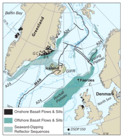
North Atlantic Igneous Province (NAIP) is one of the largest and the most thoroughly documented large igneous provinces (LIPs) on Earth. It has a total area over a million square kilometres and volume over 6.6 M km3, with combined onshore and offshore remnants of volcanic sequences in Baffin Island and West Greenland, the Tugtilik–BlossevilleKyst–Scoresby Sund–Hold with Hope regions and the offshore area along the east coast of Greenland, the Faeroe Islands, Northern Ireland and northwest Scotland (British Tertiary Volcanic Province), and the aseismic ridges connecting Iceland to either margin of the Central North Atlantic (Fig. 1). Greenland was joined to Europe prior to the onset of a large-scale volcanism across the NAIP in the Paleocene. Conditions in the mantle beneath this region changed in a dramatic way at ∼61 Ma, producing basaltic magma in widespread but separate localities, which is interpreted as the result of mantle plume uplift. The continental rifting developed at about 55 Ma, with voluminous remnants along two conjugate rifted margins (Fig. 3), resulting in the separation of Greenland from the Eurasian plate. The magmatism has continued at the present time with volcanic activity focused in Iceland.
Geochronology
Dating data are mainly from K-Ar and Ar-Ar methods, with a minor percentage of U-Pb, Re-Os and Rb-Sr results. A total of approximately 700 ages of toleritic and alkaline rocks have been reported so far, ranging from 117 to 0.19 Ma, 130 reliable ages of which are between 64 to 13 Ma (Wilkinson et al., 2017). The Pre-rifted magmatism started in the early Paleocene (c. 64–63 Ma) and continued into the Eocene (c. 56 Ma), which is thought to have been related to the initial arrival of plume-head material (e.g. Saunders et al., 1997; Tegner et al., 1999, 2008; Storey et al., 2007b). The magmatic activity peaked at 61 Ma, with predominantly basaltic, but also some alkalic and picritic magmas erupting from beneath thick continental lithosphere simultaneously in a roughly circular area from Baffin Island, to the western and eastern margins of Greenland, to the Faeroe Islands and the western British Isles (Storey et al., 2007b). The second episode of volcanism took place between 56 and 50 Ma, linked with continental rifting, plate separation and shallow decompressional melting of the mantle (Saunders et al., 1997; Storey et al., 2007b). During this time, melt production rate increased significantly along the east margin of Greenland and its complement on the NW European margin. Numerous intrusions extended the activity from around 50 to 35 Ma, with the youngest recorded at approximately 20 Ma during the initial plate breakup/opening of the North Atlantic Ocean (Wilkinson et al., 2017).
Composition and geochemistry
The main activity within the NAIP consists principally of tholeiitic basaltic, alkali basaltic and picritic magmatism. There is good evidence from whole-rock elemental and isotopic characteristics that the continental lithosphere has strongly influenced the composition of the erupted rocks, in particular the earliest episode of magmatism, reflected by the ubiquitous contamination of amphibolite- to granulite-facies crusts (Saunders et al., 1997). The pre-rift magmatism (c.62–57 Ma) is characterized by highly contaminated magmas with enrichment in incompatible elements, high 87Sr/86Sr ratios, low εNd values and/or high 207Pb/204Pb and 208Pb/204Pb ratios (Saunders et al., 1997 and references therein; Day, 2016). For example, comparing to the average normal mid-ocean-ridge basalt (MORB) (εNd = 9.25, 87Sr/86Sr = 0.70273; White, 2010), the Faeroes basalts have a much higher 87Sr/86Sr ratio (c. 0.710) and lower εNd value (-10), indicating a significant addition of continental crusts (Saunders et al., 1997). Most samples from the voluminous breakup phase of magmatism (c. 56–54 Ma) have Sr–Nd–Pb isotope compositions that overlap with those of asthenospheric melts as represented by recent Icelandic basalts and North Atlantic MORB, indicating a significant decrease in the extent of continental contamination.
Formation
A mantle plume is the most adopted hypothesis to interpret the eruption and emplacement of NAIP, although various models including delamination, meteorite impact, small-scale rift-related convection, and chemical mantle heterogeneities have also been proposed, because it is successfully matching with most characteristics of NAIP volcanism (e.g. Pearson et al., 1996; Saunders et al., 1997; Meyer et al., 2007; Brown and Lesher, 2015; Day, 2016; Hole and Millett, 2016). The mantle plume concept was firstly proposed by Morgan (1971). In this concept, the warm material is brought by the mantle plumes from deep mantle to the base of the lithosphere. Once arrived, mantle material flows radially away from the plume over large distances and cause widespread and simultaneous volcanic activity by decompression melting and/or melting of the lithosphere. Moreover, vertical movements associated with plume impingement would place the lithosphere under stress and thus result in lithosphere stretching and drive plate tectonics (Meyer et al., 2007). The huge area affected by NAIP volcanism, the abnormally high mantle flux rate, the development of continent rift and opening of North Atlantic Ocean can be interpreted well with the mantle plume hypothesis. The geochemistry of the NAIP is consistent with the plume hypothesis, and to a large extent with the two-stage model presented in Saunders et al. (1997). In the first stage, magmas show a geochemical diversity from mantle origination to continent contamination, which is probably associated with the arrival of the proto-Iceland plume. In the second stage, however, magmas dominantly have a geochemical signature of mid-ocean ridge basalt (MORB), which is regarded to be closely linked to continent breakup.
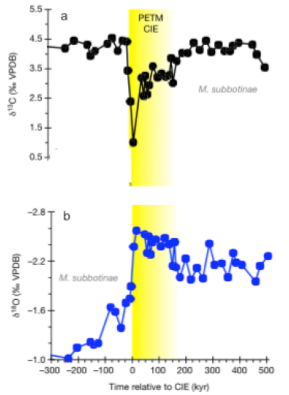
Correlation between the NAIP and PETM
The Palaeocene-Eocene Thermal Maximum (PETM) is a brief period of wide spread, extreme climatic warming event which occurred 55 million years ago. During this time, there was a sudden rise in global sea surface temperature, which was up to 6℃ in Arctic region (Sluijs et al., 2006). The initiation of the PETM is characterized by an abrupt decrease in δ13C and δ18O value of marine and terrestrial sedimentary carbon (Fig. 4), which is interpreted as the consequence of the rapid injection of massive carbon dioxide and/or methane with light carbon and oxygen isotopic composition. The abnormal Earth-surface carbon cycle is associated with a large deep-sea mass extinction event and remarkable diversification of life in the surface ocean and on land. Previous studies have dated the ash layers close to the PETM event with various methods and yield coincident ages at 55.7 – 56.0 Ma (e.g. Charles et al., 2011; Saunders, 2016). This age is consistent with the second phase magmatic activity in NAIP indicating NAIP volcanism is the main driver of the PETM. As for the source of carbon, it is commonly regarded that most were from contact metamorphism of organic-rich sediments in North Atlantic sedimentary basins and large rifting melt volumes. However, recent research reveals the volcanic carbon is also an important trigger of PETM (Gutjah et al., 2017).
References

Algeo, T., Henderson, C.M., Ellwood, B., Rowe, H., Elswick, E., Bates, S., Lyons, T., Hower, J.C., Smith, C., Maynard, B. and Hays, L.E., 2012. Evidence for a diachronous Late Permian marine crisis from the Canadian Arctic region. GSA Bulletin, 124(9-10), pp.1424-1448.

Bond, D.P. and Wignall, P.B., 2010. Pyrite framboid study of marine Permian–Triassic boundary sections: a complex anoxic event and its relationship to contemporaneous mass extinction. Bulletin, 122(7-8), pp.1265-1279.

Brown, E.L. and Lesher, C.E., 2014. North Atlantic magmatism controlled by temperature, mantle composition and buoyancy. Nature Geoscience, 7(11), p.820.

Charles, A.J., Condon, D.J., Harding, I.C., Pälike, H., Marshall, J.E., Cui, Y., Kump, L. and Croudace, I.W., 2011. Constraints on the numerical age of the Paleocene‐Eocene boundary. Geochemistry, Geophysics, Geosystems, 12(6).

Coffin, M.F. and Eldholm, O., 1994. Large igneous provinces: crustal structure, dimensions, and external consequences. Reviews of Geophysics, 32(1), pp.1-36.

Corfu, F., Polteau, S., Planke, S., Faleide, J.I., Svensen, H., Zayoncheck, A. and Stolbov, N., 2013. U–Pb geochronology of Cretaceous magmatism on Svalbard and Franz Josef Land, Barents Sea large igneous province. Geological Magazine, 150(6), pp.1127-1135.

Day, J.M., 2016. Evidence against an ancient non-chondritic mantle source for North Atlantic Igneous Province lavas. Chemical Geology, 440, pp.91-100.

Dustira, A.M., Wignall, P.B., Joachimski, M., Blomeier, D., Hartkopf-Fröder, C. and Bond, D.P., 2013. Gradual onset of anoxia across the Permian–Triassic Boundary in Svalbard, Norway. Palaeogeography, Palaeoclimatology, Palaeoecology, 374, pp.303-313.

Grasby, S.E., Sanei, H. and Beauchamp, B., 2011. Catastrophic dispersion of coal fly ash into oceans during the latest Permian extinction. Nature Geoscience, 4(2), p.104.

Grogan, P., Nyberg, K., Fotland, B., Myklebust, R., Dahlgren, S. and Riis, F., 2000. Cretaceous magmatism south and east of Svalbard: evidence from seismic reflection and magnetic data. Polarforschung, 68, pp.25-34.

Gutjahr, M., Ridgwell, A., Sexton, P.F., Anagnostou, E., Pearson, P.N., Pälike, H., Norris, R.D., Thomas, E. and Foster, G.L., 2017. Very large release of mostly volcanic carbon during the Palaeocene–Eocene Thermal Maximum. Nature, 548(7669), p.573.

Hole, M.J. and Millett, J.M., 2016. Controls of mantle potential temperature and lithospheric thickness on magmatism in the North Atlantic Igneous Province. Journal of Petrology, 57(2), pp.417-436.

Jakobsson, M., Mayer, L., Coakley, B., Dowdeswell, J.A., Forbes, S., Fridman, B., Hodnesdal, H., Noormets, R., Pedersen, R., Rebesco, M. and Schenke, H.W., 2012. The international bathymetric chart of the Arctic Ocean (IBCAO) version 3.0. Geophysical Research Letters, 39(12).

Jerram, D.A. and Bryan, S.E., 2018. Plumbing systems of shallow level intrusive complexes. In Physical Geology of Shallow Magmatic Systems (pp. 39-60). Springer, Cham.

Jones, A.P., Price, G.D., Price, N.J., DeCarli, P.S. and Clegg, R.A., 2002. Impact induced melting and the development of large igneous provinces. Earth and Planetary Science Letters, 202(3-4), pp.551-561.

Jones, M.T., Jerram, D.A., Svensen, H.H. and Grove, C., 2016. The effects of large igneous provinces on the global carbon and sulphur cycles. Palaeogeography, Palaeoclimatology, Palaeoecology, 441, pp.4-21.

Maher, Jr, H.D., 2001. Manifestations of the Cretaceous High Arctic large igneous province in Svalbard. The Journal of Geology, 109(1), pp.91-104.

Meyer, R., Van Wijk, J. and Gernigon, L., 2007. The North Atlantic Igneous Province: A review of models for its formation. Geological Society of America Special Papers, 430, pp.525-552.

Nejbert, K., Krajewski, K.P., Dubinska, E. and Pecskay, Z., 2011. Dolerites of Svalbard, north-west Barents Sea Shelf: age, tectonic setting and significance for geotectonic interpretation of the High-Arctic Large Igneous Province. Polar Research, 30(1), p.7306.

Ogden, D.E. and Sleep, N.H., 2012. Explosive eruption of coal and basalt and the end-Permian mass extinction. Proceedings of the National Academy of Sciences, 109(1), pp.59-62.

Pearson, D.G., Emeleus, C.H. and Kelley, S.P., 1996. Precise 40Ar/39Ar age for the initiation of Palaeogene volcanism in the Inner Hebrides and its regional significance. Journal of the Geological Society, 153(6), pp.815-818.

Reichow, M.K., Saunders, A.D., White, R.V., Pringle, M.S., Al'Mukhamedov, A.I., Medvedev, A.I. and Kirda, N.P., 2002. 40Ar/39Ar dates from the West Siberian Basin: Siberian flood basalt province doubled. Science, 296(5574), pp.1846-1849.

Reichow, M.K., Pringle, M.S., Al'Mukhamedov, A.I., Allen, M.B., Andreichev, V.L., Buslov, M.M., Davies, C.E., Fedoseev, G.S., Fitton, J.G., Inger, S. and Medvedev, A.Y., 2009. The timing and extent of the eruption of the Siberian Traps large igneous province: Implications for the end-Permian environmental crisis. Earth and Planetary Science Letters, 277(1-2), pp.9-20.

Renne, P.R. and Basu, A.R., 1991. Rapid eruption of the Siberian Traps flood basalts at the Permo-Triassic boundary. Science, 253(5016), pp.176-179.

Retallack, G.J., Veevers, J.J. and Morante, R., 1996. Global coal gap between Permian–Triassic extinction and Middle Triassic recovery of peat-forming plants. Geological Society of America Bulletin, 108(2), pp.195-207.

Rothman, D.H., Fournier, G.P., French, K.L., Alm, E.J., Boyle, E.A., Cao, C. and Summons, R.E., 2014. Methanogenic burst in the end-Permian carbon cycle. Proceedings of the National Academy of Sciences, 111(15), pp.5462-5467.

Sahney, S. and Benton, M.J., 2008. Recovery from the most profound mass extinction of all time. Proceedings of the Royal Society of London B: Biological Sciences, 275(1636), pp.759-765.

Saunders, A.D., Fitton, J.G., Kerr, A.C., Norry, M.J. and Kent, R.W., 1997. The north Atlantic igneous province. Large igneous provinces: Continental, oceanic, and planetary flood volcanism, 100, pp.45-93.

Saunders, A.D., 2016. Two LIPs and two Earth-system crises: the impact of the North Atlantic Igneous Province and the Siberian Traps on the Earth-surface carbon cycle. Geological Magazine, 153(2), pp.201-222.

Senger, K., Tveranger, J., Ogata, K., Braathen, A. and Planke, S., 2014. Late Mesozoic magmatism in Svalbard: A review. Earth-Science Reviews, 139, pp.123-144.

Shipilov, E. & Karyakin, Y., 2011. The barents sea magmatic province: geological–geophysical evidence and new 40Ar/39Ar dates. Doklady Earth Science, Volume 439, pp. 955-960.

Sluijs, A., Schouten, S., Pagani, M., Woltering, M., Brinkhuis, H., Damsté, J.S.S., Dickens, G.R., Huber, M., Reichart, G.J., Stein, R. and Matthiessen, J., 2006. Subtropical Arctic Ocean temperatures during the Palaeocene/Eocene thermal maximum. Nature, 441(7093), p.610.

Storey, M., Duncan, R.A. and Swisher, C.C., 2007a. Paleocene-Eocene thermal maximum and the opening of the northeast Atlantic. Science, 316(5824), pp.587-589.

Storey, M., Duncan, R.A. and Tegner, C., 2007b. Timing and duration of volcanism in the North Atlantic Igneous Province: implications for geodynamics and links to the Iceland hotspot. Chemical Geology, 241(3-4), pp.264-281.

Svensen, H., Planke, S., Polozov, A.G., Schmidbauer, N., Corfu, F., Podladchikov, Y.Y. and Jamtveit, B., 2009. Siberian gas venting and the end-Permian environmental crisis. Earth and Planetary Science Letters, 277(3-4), pp.490-500.

Tarduno, J.A., Brinkman, D.B., Renne, P.R., Cottrell, R.D., Scher, H. and Castillo, P., 1998. Late Cretaceous Arctic volcanism: tectonic and climatic connections. In Am. Geophys. Union Spring Meeting Abstracts. Washington, DC, Am. Geophys. Union.

Tegner, C., Duncan, R.A., Bernstein, S., Brooks, C.K., Bird, D.K. and Storey, M., 1998. 40Ar-39Ar geochronology of Tertiary mafic intrusions along the East Greenland rifted margin: Relation to flood basalts and the Iceland hotspot track. Earth and Planetary Science Letters, 156(1-2), pp.75-88.

Tegner, C., Brooks, C.K., Duncan, R.A., Heister, L.E. and Bernstein, S., 2008. 40Ar–39Ar ages of intrusions in East Greenland: Rift-to-drift transition over the Iceland hotspot. Lithos, 101(3-4), pp.480-500.

Tegner, C., Storey, M., Holm, P.M., Thorarinsson, S.B., Zhao, X., Lo, C.H. and Knudsen, M.F., 2011. Magmatism and Eurekan deformation in the High Arctic Large Igneous Province: 40 Ar–39 Ar age of Kap Washington Group volcanics, North Greenland. Earth and Planetary Science Letters, 303(3), pp.203-214.

White, W.M., 2010. Oceanic island basalts and mantle plumes: the geochemical perspective. Annual Review of Earth and Planetary Sciences, 38, pp.133-160.

Wignall, P.B. and Hallam, A., 1992. Anoxia as a cause of the Permian/Triassic mass extinction: facies evidence from northern Italy and the western United States. Palaeogeography, Palaeoclimatology, Palaeoecology, 93(1-2), pp.21-46.

Wignall, P.B., Morante, R. and Newton, R., 1998. The Permo-Triassic transition in Spitsbergen: δ 13 C org chemostratigraphy, Fe and S geochemistry, facies, fauna and trace fossils. Geological Magazine, 135(1), pp.47-62.

Wilkinson, C.M., Ganerød, M., Hendriks, B.W. and Eide, E.A., 2016. Compilation and appraisal of geochronological data from the North Atlantic Igneous Province (NAIP). Geological Society, London, Special Publications, 447, pp. SP447-10.
